A novel new drone system fitted with an array of sensors could assess methane emissions in local areas allowing researchers to zoom in on hotspots for greenhouse gas emissions.
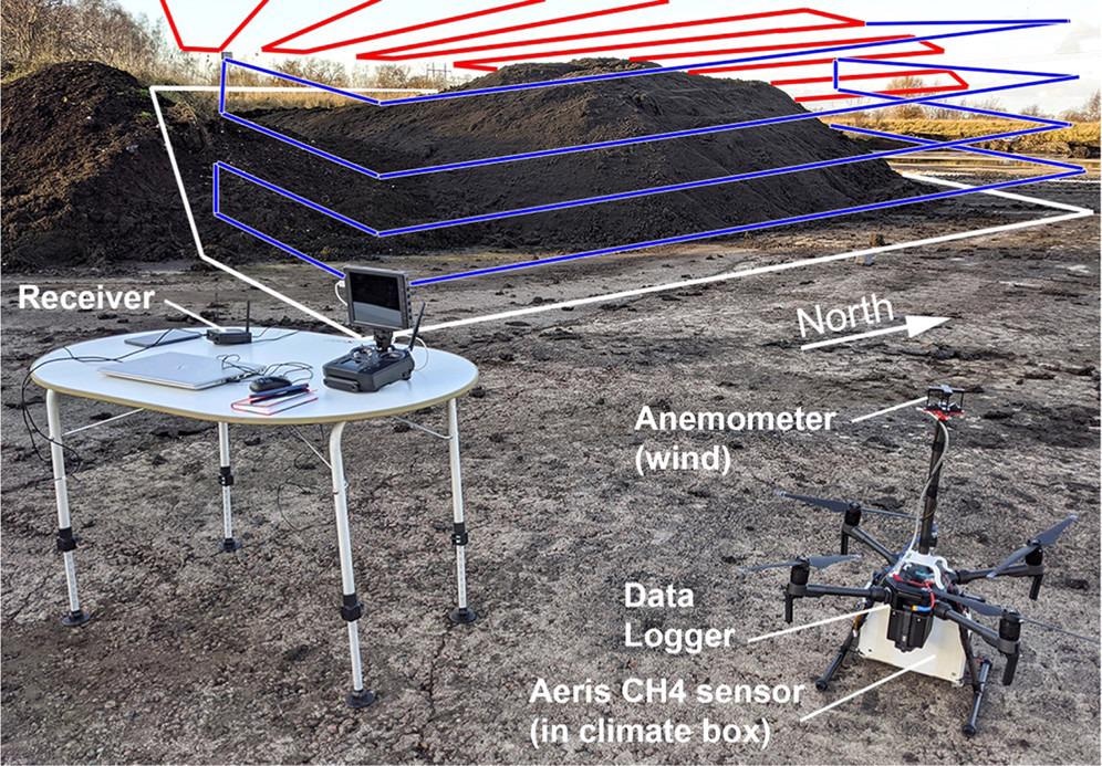 UAV system setup at the sludge deposit used for the test flights. Illustrative flight tracks are shown as red (horizontal surface above the pile for hotspot mapping) and blue curves (vertical planes for mass balance and total flux calculations). The white curve indicates the emission footprint in a no-wind situation. A receiver and laptop allowed real-time viewing of data in addition to on-board data logging. Image Credit: ACS Earth and Space Chemistry
Methane is one of the key drivers of climate change, a greenhouse gas with a ‘warming power’ that is 80 times greater than carbon dioxide. And even though the former has a more sustained, longer-lasting impact on the greenhouse effect, methane’s impact is almost immediate.
In fact, though methane only makes up 20% of all greenhouse gas emissions, it is currently estimated that a minimum of 25% of today’s warming is driven by methane produced by human activities¹. This has led to methane being labeled a ‘super pollutant’ and has made methane emission reduction a major front in the battle against climate change.
Reducing methane emissions could have some immediate benefits, helping to mitigate some of the harmful effects of climate change. And, with countries currently attempting to meet the temperature goals of the Paris Agreement, action in cutting methane emissions has never been so important.
One of the key elements in the reduction of methane emissions is knowing from where these emissions are coming. The discovery of emission sources, including those currently poorly understood, requires sensitively measuring emissions from contributors such as livestock and agricultural practices, the production and transport of coal, natural gas, and oil.
Data on methane emissions is commonly collected by satellite, and whilst this method is good for detecting methane on global and regional scales where it falters, it is in the collection of methane emission data on more localized scales.
A new paper presented in ACS Earth and Space Chemistry² introduces a novel way of monitoring methane emissions in finer detail from the air. Magnus Gålfalk of the University of Linköping, and his colleagues put forward the use of drones equipped with all the sensing equipment required to monitor emissions from methane hotspots.
The team hopes that deploying these drones will result in a sensitive and rapid, methane emission detection system for use across both small and large regions to track hotspots and estimate total emissions from a specific area without additional data from ground-based sensors.
Developing a Drone System for Methane Tracking
At the heart of the team’s system is a DJI Matrice 210 quadcopter decked out with onboard devices including GPS, pressure, temperature, and humidity sensors, a methane sensor — of course — and a camera. Also equipped is a logger to keep track of all the data being collected by these sensors.
The all-important methane sensor is an Aeris MIRA Pico — a portable middle infrared (IR) laser-based gas analyzer developed by Aeris Technologies. IR emission or absorption patterns can be used as a fingerprint for chemical compounds. This sensor can make thousands of measurements over a period of seconds, by factoring in how the gas moves, allowing the team to hone right in on the source of methane flux in a small area.
This can deliver a few surprises as to where methane is actually originating from. For instance; during their initial testing while focusing on a cow barn, Gålfalk and his research team expected the major methane contribution to be manure, but they were surprised to find a large methane flux originated from a ventilation outlet.
Another advantage of this device is that it can deliver a gas detection performance that is normally only associated with much heavier alternatives, in a compact and lightweight unit. Coupled with the fact that it can detect methane from a distance of 700 meters, its lightweight nature means the system is ideal for deployment on an aerial vehicle.
The system was also equipped with an ultrasonic anemometer mounted on a carbon fiber rod above the drone’s rotors. This enabled the team to collect data about wind speed and direction, the lack of which has hampered similar projects in the past.
Altogether the system has a total weight of just under 7 kg, which includes TB50 batteries enabling a flight time of 10 minutes, which the team discovered they could up to 30 minutes by using a system of three batteries.
With the system developed, the next step for the team was the testing. In order to do this, and model methane fluxes over an area identifying hotspots the researchers selected a site that has traditionally proved challenging for other similar systems, namely a wastewater treatment site.
Methane Detection from the Air
The team’s drone system was launched on its first test flight on 25th November 2019, allowing the researchers to test how it functioned in low-wind conditions. Its flight patterns took it above a sludge deposit, with such masses of material associated with methane flux.
During this and follow-up flights, the team collected enough data on an area from the drone to build a map of methane emission hotspots and survey a range of expected concentrations.
The results that the team presented in their paper originate mainly from drone flights conducted on January 24th, 2020, which also incorporated vertical flight patterns and the total flux of methane emissions.
Because these later tests were based upon mass balance and the vertical plane they required fewer assumptions about elements such as atmospheric stability and emissions from individual hotspots.
“This study confirms the potential of drone-based CH4 concentration mapping and flux measurements to contribute a valuable supplement to established greenhouse gas measurement techniques,” the authors say in their paper, explaining that their system would benefit from drone size to payload and flight time optimization.
The researchers also add that the system would benefit from testing in other environments so that its benefits and drawbacks can be properly assessed.
Sources
1. Overview of Greenhouse Gases, EPA, [https://www.epa.gov/ghgemissions/overview-greenhouse-gases]
2. Gålfalk. M., Påledal. S. N., Bastvike. D., [2021], ‘Sensitive Drone Mapping of Methane Emissions without the Need for Supplementary Ground-Based Measurements,’ Earth & Space Chemistry, [DOI:10.1021/acsearthspacechem.1c00106]
Disclaimer: The views expressed here are those of the author expressed in their private capacity and do not necessarily represent the views of AZoM.com Limited T/A AZoNetwork the owner and operator of this website. This disclaimer forms part of the Terms and conditions of use of this website.