Runoff in coastal waters is connected to the degradation and pollution of coral reefs and other oceanic ecosystems. Unmanned aerial vehicles (UAVs) have currently been used to surpass the challenges of tracking water flow between ecosystems and over huge regions.
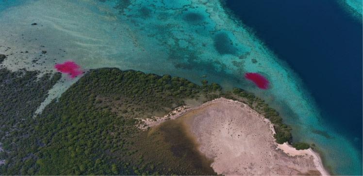 Unmanned aerial vehicles and harmless dyes can be used to monitor the movement of water between habitats along the Red Sea coast. Image Credit: © 2022 KAUST.
High-frequency airborne UAV images and flight surveys were employed by scientists at King Abdullah University of Science and Technology (KAUST) to monitor the movement of dye plumes discharged during an ebbing tide.
Headed by remote sensing scientist Kasper Johansen, the team also used data from aerial images integrated with field measurements to chart dye concentrations, offering insights into the scattering of materials in the water column and throughout the coast.
To facilitate continuous monitoring of the dye plumes, two drones flew for 80 minutes above the mangrove and seagrass areas where the dye was discharged, capturing photos every 10 seconds and delivering total coverage of the plumes. UAV flight surveys then gathered data as the plumes spread across a larger area.
Field-based dye concentration measurements were associated with the pixel values of spectral bands and indices of 30 diverse UAV images. These were taken at the precise time of each seawater sample collection to develop a connection that could be used to chart dye concentrations for the period of the ebbing tide.
Johansen explains the data acquired can offer insights into the transportation, exchange and dependencies of nutrients between seagrass, mangrove and coral reef ecosystems.
With new high spatial resolution satellite constellations becoming available and allowing sub-daily image collection, satellite-based dye-tracing experiments may be accomplished for much larger areas, with UAV data potentially bridging the gaps between field measurements and satellite image data.
Kasper Johansen, Study Lead and Remote Sensing Scientist, KAUST
Having a grasp of the dynamics and exchanges of nutrients and water throughout the coastal fringe is crucial for several research activities at KAUST.
Matthew McCabe, the director of Climate and Livability Initiative at KAUST states the study has shown the capacity of new Earth observation methods for tracking time-sensitive events and recording rapidly developing processes.
These technologies can be deployed to support some of the large-scale projects going on within Saudi Arabia.
Matthew McCabe, Director of Climate and Livability Initiative, KAUST
Studies in the future could monitor coastal water flows in different environmental settings, for example, with larger tidal ranges or deeper water. The technique could also help estimate where pollutants such as river runoff, sewage or oil spills will be shifted along the coast.
The study represents a lower cost way to visualize coastal water flows. UAVs are becoming increasingly available to scientists and private citizens, so this method offers a more accessible and cost-effective way for regular monitoring of coastal water movement.
Aislinn Dunne, Marine Scientist, KAUST
Journal Reference:
Johansen, K., et al. (2022) Dye tracing and concentration mapping in coastal waters using unmanned aerial vehicles. Scientific Reports. doi.org/10.1038/s41598-022-05189-9.
Source: https://www.kaust.edu.sa/en