Nov 18 2016
 Researchers at North Carolina State University have developed a combination of software and hardware that will allow them to use unmanned aerial vehicles (UAVs) and insect cyborgs, or biobots, to map large, unfamiliar areas -- such as collapsed buildings after a disaster. (CREDIT - Edgar Lobaton)
A team of researchers from North Carolina State University have created a combination of hardware and software that will enable them to use unmanned aerial vehicles (UAVs) and insect cyborgs, or biobots to map large, unfamiliar areas e.g., collapsed buildings following a disaster.
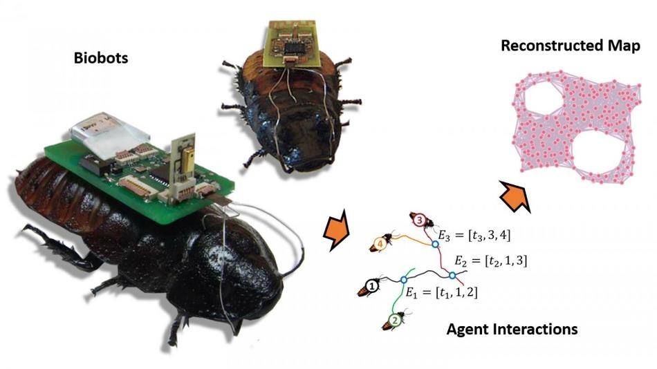
The idea would be to release a swarm of sensor-equipped biobots - such as remotely controlled cockroaches - into a collapsed building or other dangerous, unmapped area. Using remote-control technology, we would restrict the movement of the biobots to a defined area. That area would be defined by proximity to a beacon on a UAV. For example, the biobots may be prevented from going more than 20 meters from the UAV.
Edgar Lobaton, Assistant Professor, NC State
Within a defined area, the biobots would be allowed to travel freely. They would signal the researchers via radio waves every time they got close to each other. Custom software would then apply an algorithm to interpret the biobot sensor data into an approximate map of the unfamiliar environment.
When the program receives enough data to map the defined area, the UAV moves forward to hover over the next closest unknown section. The biobots travel along with it, and the mapping process is performed again. The software program then stitches the newly created map to the earlier one. This process can be done over and over again until the total area or structure has been mapped. The final map can be used by first responders or other authorities.
This has utility for areas – like collapsed buildings – where GPS can’t be used. A strong radio signal from the UAV could penetrate to a certain extent into a collapsed building, keeping the biobot swarm contained. And as long as we can get a signal from any part of the swarm, we are able to retrieve data on what the rest of the swarm is doing. Based on our experimental data, we know you’re going to lose track of a few individuals, but that shouldn’t prevent you from collecting enough data for mapping.
Edgar Lobaton, Assistant Professor, NC State
Co-lead author Alper Bozkurt, an associate professor of electrical and computer engineering at NC State, has previously built functional cockroach biobots. However, to try out their new mapping technology, the team depended upon inch-and-a-half-long robots that imitate cockroach behavior.
During their experiment, the researchers launched these robots into a maze-like space, with the effect of the UAV beacon copied using an overhead camera and a physical boundary connected to a moving cart. The cart was moved as and when the robots mapped the area.
We had previously developed proof-of-concept software that allowed us to map small areas with biobots, but this work allows us to map much larger areas and to stitch those maps together into a comprehensive overview. It would be of much more practical use for helping to locate survivors after a disaster, finding a safe way to reach survivors, or for helping responders determine how structurally safe a building may be. The next step is to replicate these experiments using biobots, which we’re excited about.
Edgar Lobaton, Assistant Professor, NC State
An article on the framework for creating local maps and stitching them together, “A Framework for Mapping with Biobotic Insect Networks: From Local to Global Maps,” is published in Robotics and Autonomous Systems.
An article on the theory of mapping according to the proximity of mobile sensors to each other, “Geometric Learning and Topological Inference with Biobotic Networks,” is published in IEEE Transactions on Signal and Information Processing over Networks. The third co-lead author on both papers is Alireza Dirafzoon, a former Ph.D. student at NC State. The research was supported by the National Science Foundation under grant CNS-1239243.
Dynamic Topological Mapping with Hexbugs