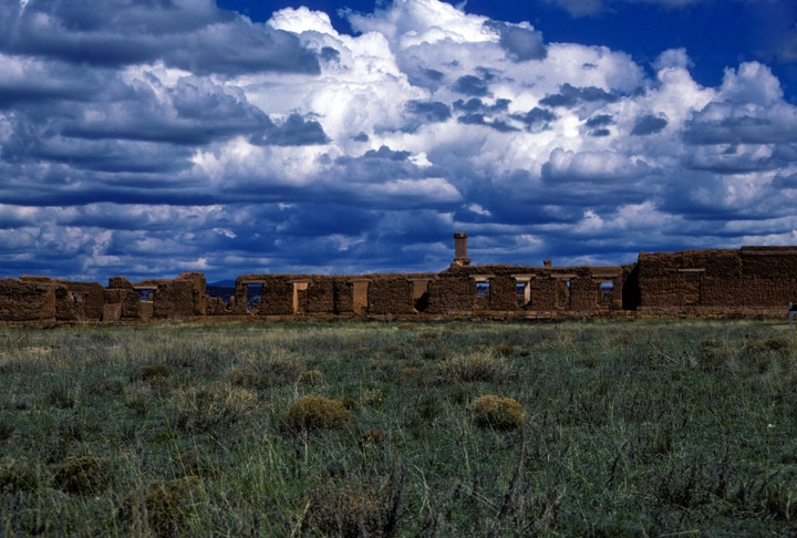
For Frank Matero adobe structures are the “canaries in the coal mine” for climate change adaptation. Building ruins such as those at Fort Union National Monument in New Mexico, which Matero’s Center for Architectural Conservation has been exploring for more than three years, provide the ideal laboratory to explore risk, vulnerability, threat, and resistance. Any damage that climate change might do to exposed structures; it will first do it to adobe.
 (Credit: Penn Today Staff)
The reason we’re at Fort Union now is that the park has experienced unprecedented catastrophic collapses over the last two years,” “I think we’re going to see more and more of this. The point of the research is to develop a framework for identifying the specific conditions and site aspects such as exposure that indicate vulnerability before catastrophic failure.
Frank Matero, Professor and Chair of the Graduate Program in Historic Preservation, PennDesign.
Progressively, the lab is looking to new technology to answer that question, particularly UAVs (drones) and remote sensing.
At the Center, research specialist and PennDesign lecturer John Hinchman is testing with drones to observe vulnerable areas in conservation sites like Fort Union, and research associate Evan Oskierko-Jeznacki is employing RFID technology to develop sensors that can be positioned inside the adobe walls and produce data about moisture levels. Oskierko-Jeznacki says the tiny RFID sensors have immense promise for monitoring, because they are inexpensive and less invasive compared to traditional approaches. The team traveled to Fort Union in June and July to formulate a methodology for establishing the vulnerability of the site’s adobe walls.
The sensor that Oskierko-Jeznacki developed is not any bigger than the ones that are slipped into the merchandise at chain bookstores. It can feed data to an antenna about whether there is moisture within an adobe wall, which could mean it is necessary to remediate. The antennae can be connected to drones, which can also be employed to photographically monitor exposed areas of heritage sites, the Center is finding.