Image Credit: Martin Brandt.
In a region of West Africa 30 times bigger than Denmark, an international team, headed by scientists from the University of Copenhagen and NASA, has counted more than 1.8 billion trees and shrubs.
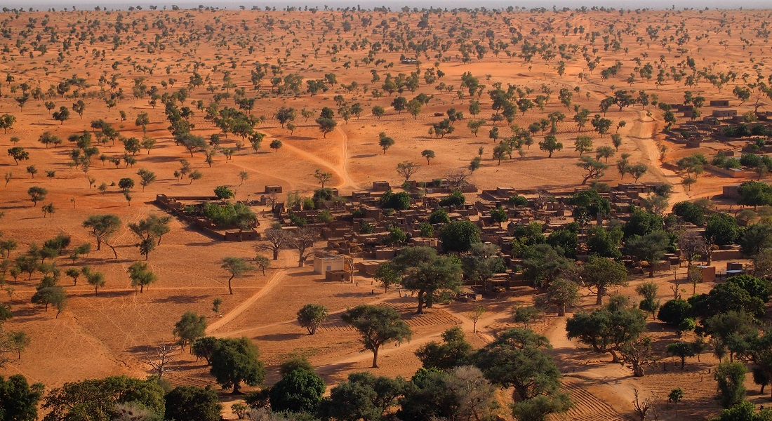
We were very surprised to see that quite a few trees actually grow in the Sahara Desert, because up until now, most people thought that virtually none existed. We counted hundreds of millions of trees in the desert alone. Doing so wouldn’t have been possible without this technology. Indeed, I think it marks the beginning of a new scientific era.
Martin Brandt, Study Lead Author and Assistant Professor, Department of Geosciences and Natural Resource Management, University of Copenhagen
The paper has been published in the Nature journal.
The research was realized through a blend of exhaustive satellite imagery delivered by NASA, and deep learning—a sophisticated artificial intelligence technique. Standard satellite imagery is incapable of identifying individual trees, which remain absolutely invisible.
Furthermore, lower interest in counting trees beyond forested areas resulted in the prevailing view that there were virtually no trees in this specific region. For the first time, trees spread over a large dryland area have been counted.
The role of trees in the global carbon budget
According to Martin Brandt, new information about trees in dryland regions like this is vital for a number of reasons. For instance, they signify an unidentified factor with regards to the global carbon budget:
“Trees outside of forested areas are usually not included in climate models, and we know very little about their carbon stocks. They are basically a white spot on maps and an unknown component in the global carbon cycle,” explains Martin Brandt.
Moreover, the new research can add to an improved understanding of the significance of trees for ecosystems and biodiversity and for the people residing in these places. Specifically, improved knowledge about trees is also vital for framing programs that boost agroforestry, which plays a huge socio-economic and environmental role in arid areas.
Thus, we are also interested in using satellites to determine tree species, as tree types are significant in relation to their value to local populations who use wood resources as part of their livelihoods. Trees and their fruit are consumed by both livestock and humans, and when preserved in the fields, trees have a positive effect on crop yields because they improve the balance of water and nutrients.
Rasmus Fensholt, Professor, Department of Geosciences and Natural Resource Management, University of Copenhagen
Technology with a high potential
The study was carried out in partnership with the University of Copenhagen’s Department of Computer Science, where scientists created the deep learning algorithm that made it possible to count trees over such a large area.
The team trained the deep learning model to recognize what a tree looks like: They did so by inputting thousands of images of different types of trees. Based on the detection of tree shapes, the model can then spontaneously identify and map trees spanning large areas and thousands of images. The model requires a few hours for what would require thousands of humans several years to accomplish.
This technology has enormous potential when it comes to documenting changes on a global scale and ultimately, in contributing towards global climate goals. It is a motivation for us to develop this type of beneficial artificial intelligence.
Christian Igel, Study Co-Author and Professor, Department of Computer Science, University of Copenhagen
For the researchers, the next step would be to increase the count to a much wider region in Africa. In the longer term, the goal is to develop a global database of all trees growing beyond forest areas.
Journal Reference:
Brandt, M., et al. (2020) An unexpectedly large count of trees in the West African Sahara and Sahel. Nature. doi.org/10.1038/s41586-020-2824-5.