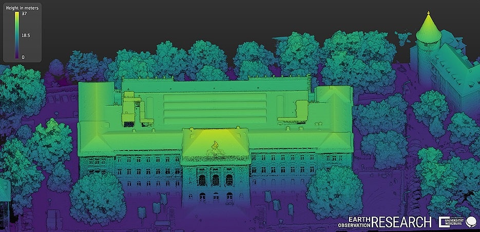
This image of the Neue Universität at Sanderring was generated from elevation data. The different colors indicate the distance to the ground. (Image Credit: Lehrstuhl für Fernerkundung / Universität Würzburg)
Earth observation, also called remote sensing, offers highly appropriate data regarding the state and change of the planet every day through satellite data available throughout the world. The data could be used, for instance, to gather information about heat islands in droughts, cities, or the condition of forests.
At present, Earth observation is setting the stage for extra data sources. Having sensors installed on drones that are available on the market is achieving additional elaborate environmental information, and at a spatial resolution at such a high level that it cannot be obtained with satellite data.
“The very high resolutions in the centimeter range open up new areas of application and research questions. We are thus gaining highly relevant information for urban research, ecology, and nature conservation.” states researcher Dr. Mirjana Bevanda from the Earth Observation Research Hub at Julius-Maximilians-Universität Würzburg (JMU), a fusion of the JMU Chairs of Remote Sensing and Global Urbanization and Remote Sensing.
Mapping Heat Islands and Urban Trees
For a feasibility study, Mirjana Bevanda, jointly with Antonio Castañeda and other collaborators, imaged the Neue Universität on Sanderring and parts of Würzburg’s Ringpark with drones in 2022.
Lidar is a form of three-dimensional laser scanning. This method as well as thermal and multispectral sensors were utilized. The latter captures nearly five to ten wavelengths of light and is hence considerably better than a simple photo camera.
The study aims to explore what added value the data gathered could provide for research in urban spaces; for instance, to record and examine urban structures or to map heat islands or urban trees.
We can use this to contribute to reducing the heat island effect with targeted countermeasures, for example.
Hannes Taubenböck, Professor, Julius-Maximilians-Universität Würzburg
This effect happens when cities retain and emit greater amounts of heat during summer. Further, drones set the stage for new options for urban trees to be mapped.
We could describe each tree individually, including its vertical structure, and draw conclusions about its vitality.
Tobias Ullmann, Professor, Julius-Maximilians-Universität Würzburg
Active in Many Study Areas
Furthermore, the research group from JMU’s Earth Observation Research Hub is active with drones in Canada and other study areas.
Data acquisition with drones is very time-consuming, among other things because of the necessary approval procedures. But the data obtained and especially its level of detail is very relevant for many research questions.
Tobias Ullmann, Professor, Julius-Maximilians-Universität Würzburg
The Würzburg studies concentrate on methodological methods to make data acquisition and its processing highly effective.
“In the long term, we want to gain new insights for Earth observation from this work, which in turn can be transferred to space-based systems,” Stated Mirjana Bevanda.
Also, relationships exist with JMU Informatics. “We do field work and evaluate the data obtained for environmental research. But developing new sensors and systems is not our expertise. Here we see great potential in cooperation with various computer science working groups,” states Hannes Taubenböck.
Use in the EAGLE Master’s Program
In the studies performed on Earth observation with research drones, the experts refer to Unoccupied Aerial Systems (UAS), which links into teaching at the international Würzburg Master’s program EAGLE (Applied Earth Observation and Geoanalysis of the Living Environment). Ultimately, it is necessary for the future generation of scientists to be trained in this field.
Antonio Castañeda, an EAGLE alumnus from Colombia, is one among those who were a part of the study. He is currently a Ph.D. student at the Earth Observation Research Hub, concentrating on UAS-based remote sensing research.
“Integrating UAS into teaching gives students completely new experiences in mission planning, sensor geometry, data management, and analysis,” stated Tobias Ullmann.
Hence, they encountered new difficulties that generally do not subsist in space-based Earth observation.