Jan 19 2015
Timothée Produit of EPFL’s LASIG lab was part of our Namibian mission in May 2014. During the mission, Tim gave lectures both at the Polytechnic of Namibia as well as at the Gobabeb Research & Training Center on how to use the acquired drone imagery to classify terrain. Once all the imagery of the mission had been processed back home in Switzerland, Tim went on to use our data for classification purposes.
 © 2015 EPFL
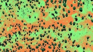
Aerial photographs, such as those obtained with ultralight drones offer a unique perspective on landscape dynamics. Through a process called orthorectification, raw aerial images are transformed into orthoimages – images with the same geometric properties as maps (i.e. where optical deformations such as those due to perspective are corrected). Multiple orthoimages can be stitched together to form an orthomosaic – a paramount product to update maps and provide a detailed view of the landscape. However, without further processing to produce more abstracted (read less detailed) representations, orthoimagery may only have a limited value for casual users such as farmers. Indeed, the power of maps resides in the simplification and abstraction of details to highlight specific topics (e.g. social, environmental, economic, etc).
In a post recently published by Drone Adventures, it is shown how to create a savanna vegetation basemap by employing supervised classification. In this context, the purpose of classification is to associate each pixel of the orthoimage with a specific land cover class. We will illustrate a simple scheme to classify a NIR (i.e. Near Infra-Red) orthomosaic into four basic classes (trees, bare soil, grass and shadow).
Source: Laboratoire de systèmes d'information géographique