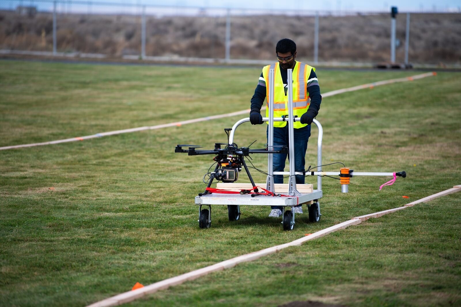
Researcher Harish Reddy Gadey walks a test path as a human surveyor, using a rolling cart to collect radiological data for comparison to the data collected by the same survey devices attached to a flying drone. (Image Credit: Graham Bourque | Pacific Northwest National Laboratory)
They are known as tools for search and rescue, weather monitoring, traffic monitoring, and probably even package hauling.
One day, they might work with humans to magnify the task of performing surveys to detect low levels of radiation—data that could add up to the decommissioning of sites no longer required for nuclear-related energy production or research.
The scientists of the Pacific Northwest National Laboratory (PNNL) discovered that drones could conduct decommissioning radiological surveys, but additional research is required before the devices have been approved for decommissioning purposes.
The PNNL scientists elaborated their outcomes for the US Nuclear Regulatory Commission (NRC) in the recently released proof-of-concept report, “Drones for Decommissioning.”
Drones would be particularly useful in areas that are unsafe for humans to access due to things like terrain that’s difficult to walk on. Drones could also survey vertical surfaces that humans can't get to like the outside of a tall building.
Amoret Bunn, Study Author and Environmental Engineer, Pacific Northwest National Laboratory
Low and Slow
Decommissioning surveys have been performed at former nuclear power plants and at former buildings or sites where radiological materials were present to illustrate that a site is in conformity with regulations and could be released for alternative uses.
In the study performed to evaluate drones for radiological detection, an experiment was performed by scientists at an open field on the PNNL campus in Richland, Washington. The experiment made a comparison of the capacity of a flying drone carrying radiological survey equipment with similar survey equipment secured to a rolling cart.
The cart was selected since it could best copy human-collected data to compare with the flying drone.
The drone was known to be a six-propeller Aurelia X6, made by UAV Systems International, capable of carrying a payload of up to 11 pounds. A Federal Aviation Administration licensed pilot made the drone operate.
A space given below the battery platform and above the landing gear housed a payload and provided safety for fragile instruments. That payload consisted of a data logger, a radiation detector, and also a geography sensing system. It was safeguarded to the drone with tailored 3D-printed casings.
The rolling imitator and flying drone traveled the same prescribed path in search of the same radiological elements that scientists had positioned on the field: small samples of cesium-137 (Cs-137), cobalt-60 (Co-60), and americium-241 (Am-241).
Both the drone and the human-propelled device executed around 1 to 3 ft above the surface. Altitude proved to be an important factor in the flying drone’s potential to gather radiological data.
Also, external factors like wind and weather changes need to be taken into account, stated PNNL physicist Harish Reddy Gadey.
At most decommissioning sites, we are looking at very low levels of radiation. We need to be as close to the ground as possible, going as slow as possible to detect some of these very low levels of radiation. For a drone, flying low and slow is not typical.
Harish Reddy Gadey, Study Author and Physicist, Pacific Northwest National Laboratory
Gadey played a main role in crafting the experiment while he was still a postdoc.
Good Potential
Already, drones have a significant role in radiation monitoring and the nuclear industry across the world. Those fitted with radiological detection systems assess radiation for incident cleanup and response.
Drones are utilized to develop contamination maps at legacy uranium sites, track and detect radiation leaks, create visual inspections at nuclear facilities, and perform unattended radiological measurements. Following the Fukushima Daiichi nuclear power plant disaster in Japan, drones evaluated the condition of the damaged reactor.
The NRC’s mission is to protect public health and the environment. This work by PNNL advances this mission and makes the use of drone technology possible for these applications.
Stephanie Bush-Goddard, Drone Project Lead, NRC Future Focused Research Program
The study came to a conclusion with suggestions for entire enhancements in drone performance as well as upgrades to the flying drone that would make it ideally suited for a decommissioning radiological survey.
Among other things, the study states, “once additional research and instrumentation improvements are complete, NRC could provide guidance on the compliance with UAV [drone] usage at decommissioning sites with consideration of aviation safety.”
At last, Gadey stated that, survey-suitable drones could probably be programmed to execute remotely at a site, in the absence of constant piloting.
Besides Bunn and Gadey, the PNNL team included scientists Katie Wagner, Debbie Fagan, Tracy Ikenberry, Kameron Markham, and Moses Obiri.
Drones for nuclear regulatory decommissioning
Pacific Northwest National Laboratory researchers found that drones have potential to conduct decommissioning radiological surveys, as detailed for the US Nuclear Regulatory Commission in the proof-of-concept report, “Drones for Decommissioning.” (Video Credit: Pacific Northwest National Laboratory)